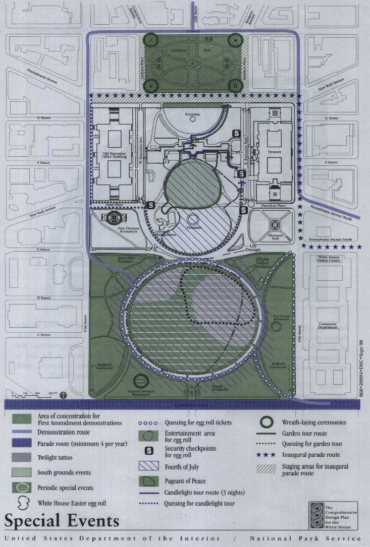
Garden Tours
Christmas Candlelight Tours
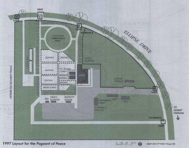
Christmas Pageant of Peace
Other Public Events
Presidential Inaugural Parade
Special Events and Demonstrations
between 15th and 17th Streets. The presidential reviewing box is constructed in front of the White House, and media stands are constructed on the opposite side of the street on the sidewalk and within Lafayette Park.
Local Street Network
Physical Characteristics
Operational Characteristics
(1) Commuting or local traffic passing through the area.
(2) Traffic parking within the study area- Drivers are usually searching for on street parking or going to one of the off street parking facilities.
(3) Tourist traffic viewing the White House and President's Park - These vehicles are driving around the area, with no set circulation pattern. Traffic drives along H Street or E Street, usually at a slower speed than general traffic, with vehicles often stopping in the travel lanes as people take photographs.
(4) Traffic accessing the Old Executive Office Building, the Treasury Building, or the White House - This group typically uses various access routes and proceeds to either East Executive Park or West Executive Avenue for entrance into the secured area. Pennsylvania Avenue is the major access route to the north side of the White House. There is no set circulation pattern.
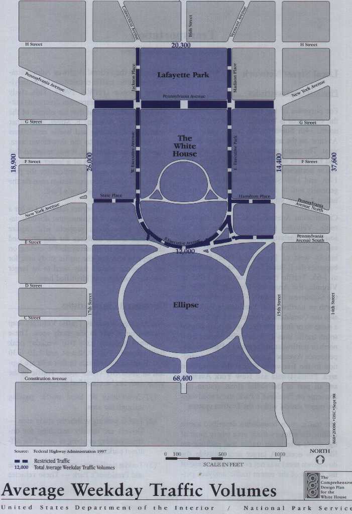
Transportation
|
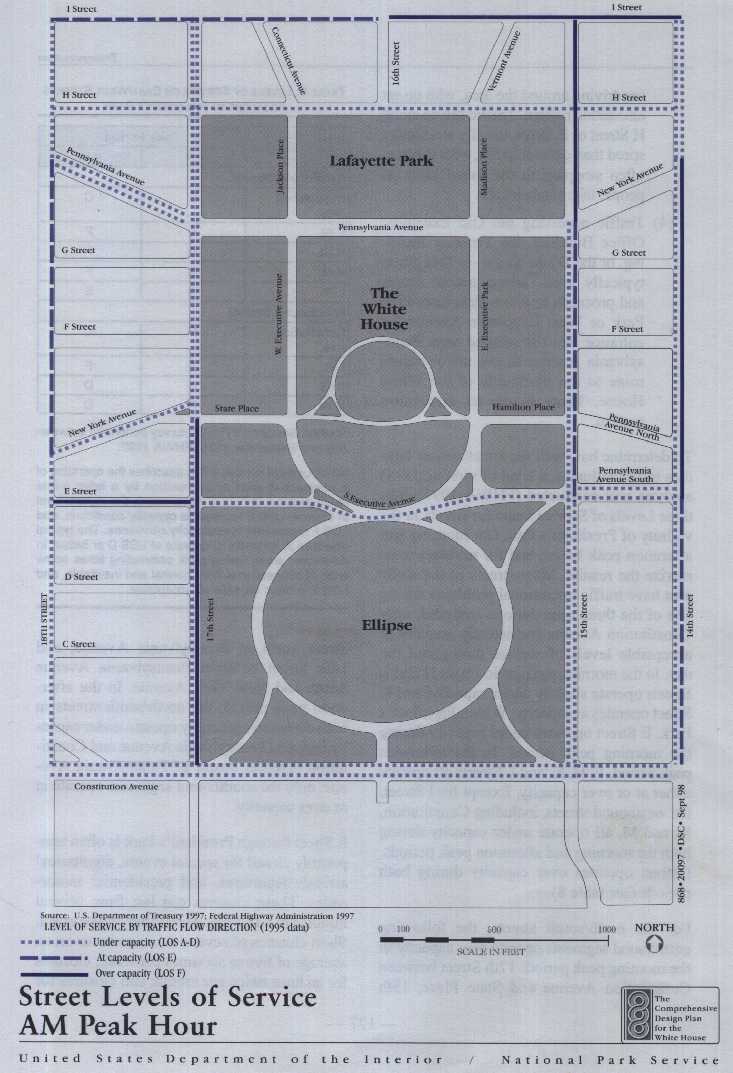
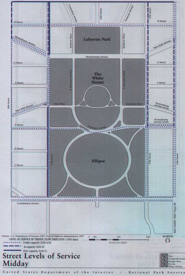
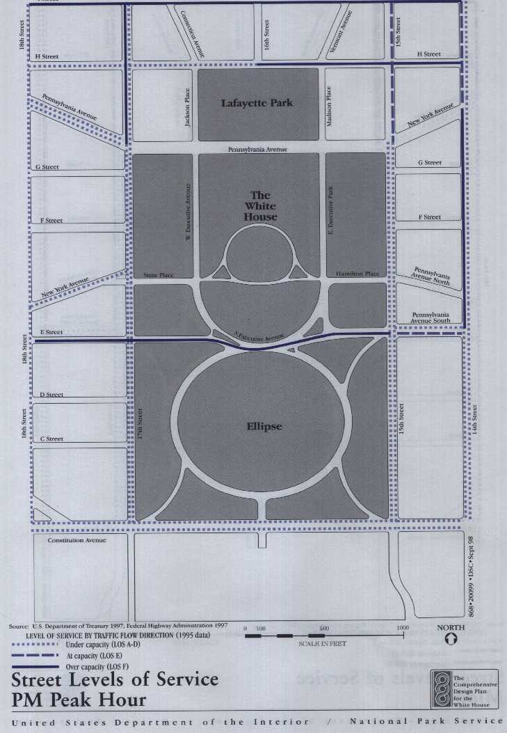
LEVELS OF SERVICE ON EAST/WEST STREETS ADJACENT TO PRESIDENT'S PARK |
||
|
|
||
| A.M. | P.M. | |
| EASTBOUND STREETS | ||
| Constitution Ave. | B | C |
| E St. | A | F |
| H St. | D | F |
| K St. | E | F |
| L St. | D | E |
| Westbound Streets | ||
| Constitution Ave. | C | C |
| I St. | F | F |
| K St. | D | D |
| M St. | D | D |
| SOURCE: Based on a FHWA survey performed between July and September 1995; FHWA 1997. | ||
| NOTE: Level of service (LOS) describes the operation of a segment of road or intersection by a letter grade ranging from A to F. LOS A represents the highest level of service, LOS E represents capacity conditions, and LOS F represents overcapacity conditions. The typical objective is for traffic to operate at LOS D or better. In downtown areas during peak commuting times some level of congestion is both normal and inevitable, and LOS E is often considered acceptable. | ||
Site Access
*The subway is the most common mode of transportation' used by 34% of the people on congressional tours and 27% of the people on public tours.
*Private vehicles account for 22%--23% of the people on both the congressional tours and the public tours.
|
|
||||||||
| . |
|
|
||||||
| MODE | Fall | Spring | Summer | Total | Fall | Spring | Summer | Total |
| Private Vehicle | 21% | 22% | 25% | 23% | 24% | 18% | 25% | 22% |
| Subway | 28% | 34% | 39% | 34% | 30% | 22% | 28% | 27% |
| Cab | 22% | 20% | 16% | 19% | 4% | 6% | 7% | 6% |
| BUS | 6% | 5% | 3% | 4% | 4% | 5% | 3% | 4% |
| Tour Bus | 8% | 3% | 1% | 4% | 14% | 27% | 19% | 20% |
| Walk | 13% | 15% | 15% | 14% | 22% | 21% | 16% | 20% |
| Other | 2% | 1% | 1% | 1% | 3% | 1% | 2% | 2% |
| SOURCE: Univ. Of Idaho, CPSU 1993 | ||||||||
| NOTE: Sizes Of visitor groups sampled: | ||||||||
| . |
|
|
||||||
| Fall |
|
|
||||||
| Spring |
|
|
||||||
| Summer |
|
|
||||||
| Total |
|
|
||||||
THE AFFECTED ENVIRONMENT
*Taxis are used by about 19% of the congressional tour visitors, but only 6% of public tour visitors arrive by cab. One possible reason for this difference could be the early hour of the congressional tours; people do not want to be late, so they are more likely to take a cab.
*Tour buses are more likely to be used by people taking public tours, with approximately 20% of public tour visitors arriving by this mode, compared to only 4% for congressional tour visitors.
*Approximately 14% of visitors on congressional tours and 20% of visitors on public tours walk to the site.
Public Parking
Public, Visitor, and Other On-Street Parking
Parking within President's Park
Parking within Three Blocks of President's Park
Transportation
|
ON-STREET PARKING SUPPLY BY REGULATION AND LOCATION IN PRESIDENT'S PARK |
|||||||
| . |
|
|
|
. | |||
| LOCATION | NPS PERMIT | PERMIT & HANDICAP | TIME-LIMITED | METERED | SIGHTSEER | VENDOR | TOTAL |
| 15th Street (west side) | |||||||
| Between Pennsylvania Ave / New York Ave. and Hamilton Pl. | . | . | . | . | . | . |
|
| Between Hamilton Pl. and Pennsylvania Ave. South | . | . | . | . | . | . |
|
| Between E St. and Constitution Ave. | . | . | . | . |
|
|
|
| 17th Street (east side) | |||||||
| Between Pennsylvania Ave. and State Pl. | . |
|
. | . | . | . |
|
| Between State Pl. and E St. | . | . |
|
|
. | . |
|
| Between E St. and Constitution Ave. | . | . |
|
|
. |
|
|
| Ellipse and Doglegs |
|
|
. | . | . | . |
|
| East Executive Park / West Executive Ave. | |||||||
| East of White House | . |
|
. | . | . | . |
|
| West of White House | . |
|
. | . | . | . |
|
| Constitution Ave. (north side) | . | . |
|
. | . | . |
|
| E St. (inside President's Park) | . |
|
. | . | . | . |
|
| State Pl. | . |
|
. | . | . | . |
|
| Jackson Pl | . |
|
. | . | . | . |
|
| Madison Pl | . | . | . | . | . | . |
|
| Hamilton Pl. | . |
|
. | . | . | . |
|
| H St. (south side) | |||||||
| Between 17th St and Vermont Ave. | . | . | . | . | . | . |
|
| Between Vermont Ave. and 15th St. | . | . | . | . | . | . |
|
| Subtotal |
|
|
|
|
|
|
. |
| Total | . |
|
. |
|
. |
|
|
| SOURCE: Parking inventory, Nov. 1994, July 1996, and Aug. 1997 by BRW, Inc. | |||||||
| * Does not include parking spaces inside the security fence. Includes on-street spaces within the inventory area (from the south side of H St. to the north side of Constitution Ave., and from the west side of 15th St. to the east side of 17th St.). | |||||||
THE AFFECTED ENVIRONMENT
Vermont Ave between K and I Streets, along the east side of Vermont Ave between I and H. and along the east and west sides of 12th Street between Constitution and Madison.
Tour Bus Parking
Public Transit
Metrorail
|
|
||
| Station | Location | Lines Served |
| McPherson Square | I St. & Vermont Ave. | Blue, Orange |
| Faragutt West | I St & 18th St. | Blue, Orange |
| Metro Center | G St & 12th St | Blue, Orange, Red |
| Federal Triangle | Pennsylvania Ave & 12th St | Blue, Orange |
| SOURCE: Metro System Route Map, Virginia and DC, January 1994. | ||
Metrobus
Tourmobile and Tour Bus Circulation
Transportation
Tour Buses
Tourmobiles
*left turns from Constitution Avenue to Ellipse Drive because of having to cross four traffic lanes on Constitution Avenue
*delays on Ellipse Drive because of the narrow roadway and conflicts with parked vehicles and careless parking in difficult spaces
THE AFFECTED ENVIRONMENT
* service disruption when traffic on the Ellipse is halted for helicopter departures from the south lawn area
Pedestrians
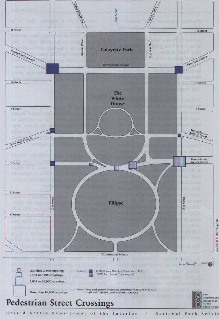
*Weekday morning peak period - The busiest intersection weekdays 6:30 to 9:30 A.M. is Pennsylvania Avenue / 17th Street, followed by Pennsylvania Avenue South / 15th Street and New York Avenue / 15th Street. It is likely most of these pedestrians are commuters, plus a much smaller number of visitors arriving from the Farragut West, the McPherson Square, and the Federal Triangle Metrorail stations. The volume of pedestrians at the Pennsylvania Avenue South / 15th Street intersection includes visitors to the White House and the White House visitor center.
Since morning counts were taken only at the Constitution Avenue / 15th Street intersection, it is not possible to quantify the number of commuters and visitors entering President's Park during this time period from the south.
*Weekday midday peak period - The busiest intersections at midday (11:30 A.M. to 2:30 P.M.) are Pennsylvania Avenue / 17th Street, New York Avenue / 15th Street, and Pennsylvania Avenue South / 15th Street. Concentrations of pedestrians at the Pennsylvania Avenue intersections include a mix of visitors entering the study area from Metrorail stations, visitors circulating in the area, and local business people. There are also fewer recreational users, such as joggers and in-line skaters.
Intersection volumes along Constitution Avenue include visitors, local business people, and recreational users circulating between this area and the National Mall and along the south side of Constitution Avenue.
|
|
|||
| Intersection |
|
|
|
| Pennsylvania Ave. / 17th St. |
|
|
|
| New York Ave. / 15th St. |
|
|
|
| New York Ave. / 17th St. |
|
|
|
| Hamilton Pl. / 15th St. |
|
|
|
| E St. / 17th St. |
|
|
|
| Constitution Ave. / 15th St. |
|
|
|
| E Street Crosswalks | |||
| Pennsylvania Ave. South / 15th St. |
|
|
|
| East Executive Ave. |
|
|
|
| West Executive Ave. |
|
|
|
| SOURCE: Intersection data are from a June-September 1995 survey by the Federal Highways Administration. E Street crosswalk data are from an August 1997 survey by BRW, Inc. | |||
| * Does not include White House tour groups. | |||
Transportation
* Weekday afternoon peak period - Afternoon pedestrian traffic (from 4 to 7 P.M.) is concentrated at the intersections of Pennsylvania Avenue / 17th Street, New York Avenue / 17th Street, New York Avenue / 15th Street, and Pennsylvania Avenue / 15th Street due primarily to commuters leaving the area by means of the Metro system. Pedestrian activity is also concentrated at the intersections of New York Avenue / 17th Street and E Street / 17th Street.
*E Street - Visitors concentrate along E Street because of the location of the White House visitor center on Pennsylvania Avenue South, the White House tour staging area on the Ellipse, and views of the White House from the south fence.
Crosswalks are designated on E Street to the west of West Executive Avenue and East Executive Park. On weekdays approximately 1,660 pedestrians cross at the West Executive Avenue crosswalk during a 12-hour period, and approximately 5,870 at the East Executive Park crosswalk. On White House tour days up to 5,000 additional crossings can be made. In addition, for the same time period, about 3,510 pedestrians (or 32%) cross E Street without using the designated crosswalks (BRW pedestrian count, August 26, 1997). Pedestrian activity was greater on a Saturday than on a Tuesday.
The E Street / 15th Street / Pennsylvania Avenue South intersection also has a high volume of pedestrian crossings as people go to and from the White House visitor center. Approximately 12,340 pedestrian crossings at this intersection were recorded for a 12-hour period on a weekday in August 1997. Again, more pedestrian crossings were recorded on a Saturday than on a weekday.
About 45% of the pedestrians crossed 15th Street on the south side of this intersection. (Crossings are not allowed on the north leg of the intersection, even though people do cross there with some difficulty.) In general, as many pedestrians crossed this intersection going north/south as they did going east/west.
Bicycles
|
WEEKDAY BICYCLE VOLUMES (PRIOR TO THE CLOSURE OF PENNSYLVANIA AVENUE) |
|||
| . |
|
||
|
|
|
|
|
| Pennsylvania Ave. / Madison Pl. | 94 | 414 | 350 |
| Pennsylvania Ave. / 17th St. | 75 | 164 | 133 |
| New York Ave. / 15th St. | 38 | 53 | 60 |
| New York Ave. / 17th St. | 32 | 28 | 103 |
| Hamilton Pl. / 15th St. | 12 | 8 | 27 |
| E St. / E. Executive Ave. | 41 | 33 | 49 |
| E St. / 15th St. | 83 | 11 | 68 |
| E St. / 17th St. | 49 | 44 | 113 |
| E St. midblock crossing (illegal) | 2 | 1 | 4 |
| Subtotal | 426 | 756 | 907 |
| Constitution Ave. / 15th St. | NA | 35 | 183 |
| Constitution Ave. / 16th St. | NA | 43 | 140 |
| Constitution Ave. / 17th St. | NA | 75 | 247 |
| Total | NA | 909 | 1,477 |
| SOURCE: 1992 survey; BRW, Inc., 1993. | |||